The Atmos fixed wing unmanned aerial vehicle remote sensing system adopts the advanced European hand thrown lightweight fixed wing unmanned aerial vehicle platform equipped with spectral imaging sensors. Its main technical features are:

ØInternational leading professional fixed wing unmanned aerial vehicle platform, winning the Social Innovation Award and the top 10 best in the world lightweight unmanned aerial vehicle platforms (1-4kg) worldwide
ØLightweight and long-lasting, with a working time of up to 1-2 hours
ØFully automatic unmanned aerial vehicle remote sensing platform, using the new generation of American 3D Robotics automatic navigation
ØHigh resolution imaging, with a resolution of up to 1cm/pixel
ØGlobal advanced ground control station, easy to plan flight operations to accurately cover target areas and required resolution and overlap, etc
ØCan be equipped with two spectral sensors (lenses) simultaneously to meet various needs, such as high-resolution RGB lenses, high-resolution RGB lenses+multispectral lenses, high-resolution RGB+hyperspectral lenses, high-resolution RGB+thermal imaging lenses, etc
ØModular cabin, customers can choose more than 2 sensors (spectral lens) and easily change different sensor combinations within a few minutes
ØComprehensive top expert support, including drone experts, telemetry experts, ecological environment experts, etc
ØInternational cooperation in drone remote sensing joint training, allowing participants to attend advanced drone remote sensing training in Europe and receive certificates


Application areas:
ØAgricultural aerial remote sensing monitoring
ØEcological environment investigation and monitoring
ØMonitoring, planning, and management of water resources
ØSoil and water conservation, soil erosion monitoring and evaluation
ØGeographic Information Systems, Earth Observation Surveying and Mapping
ØInvestigation, monitoring and evaluation of wild animals and their habitats
ØInvestigation, monitoring and early warning of forestry pests, diseases and forest fires
ØWetland resource investigation, monitoring and evaluation, nature reserve management, etc.
Technical indicators:
1. Atmos Ready-to-FlyFixed wing unmanned aerial vehicle platform:
1) MTOW:2.9kg; Maximum load 900g (sensor)
2) Effective homework time: 60-120 minutes
3) Flight mode: manual or automatic, hand thrown takeoff, automatic "deep stall" landing or parachute
4) Cruise speed: 50-60km/h; Maximum speed: 105km/h
5) Wind resistance strength: 30km/h
6) Standard configuration includes a high-resolution 20MP RGB lens, Exmor APS HD CMOS sensor, APS format, and image resolution of 5456x3632
7) The system includes: fixed wing unmanned aerial vehicle, RGB color lens, ground control station, wireless transmission and reception system, remote control, power management system including 3 batteries and chargers, portable case, etc
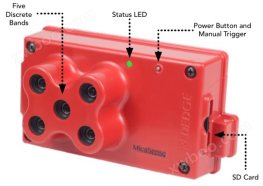
2. Multi spectral imaging sensor (optional): Blue, green, red, red edge, near-infrared five band (5 channels) multispectral imaging, per pixel 8cm@120m Height, image acquisition rate of once per second for all 5 bands, 12 bit RAW, viewing angle of 47.2 °, SD card storage for multispectral images with geotags


3. Hyperspectral imaging lens (optional): Frame frame snapshot hyperspectral camera, real image pixels, no interpolation, no IMU required:
1) CMOSSensor, pixel size5.5x5.5μm
2) Spectral range 500-900nm, optional options include 400-700nm, 450-800nm, or 550-950nm
3) Spectral resolution 10nm FWHM; Spectral peak accuracy ± 1nm
4) Lens f/2.8, focal length 9mm, FOV 36.5 degrees,Ground Resolution6.5cm/ pixel@100m
5) Maximum spectral band 380, typically 24 bands
6) Exposure time adjustable from 0.12-3000ms, frame rate 30FPS
7) Spectral image resolution: 1010x1010 pixels per band (real pixels, no interpolation)
8) Average power consumption 5.3W, operating voltage 7-9V
9)Effective pixels2D 1280x1024, frame rate5FPSSensitivity2D 400-1000nm/pixel; operation temperature-20-50 °C

4. Infrared thermal imaging (optional): resolution 640x512, band 7500-13500nm, optional 9mm, 13mm or 19mm lens
5.Velodyne LiDAR Puck LITE sensor (optional): 16 channels, measurement range of 100m, accuracy ± 3cm, vertical FOV+15.0 ° to -15.0 °, angle resolution 2.0 °, horizontal FOV 360 °, angle resolution 0.1-0.4 °, rotation rate 5-20Hz
6. Handheld or portable ground plant spectral index measuring instruments such as PlantPen and SpectraPen, or FluorCam portable chlorophyll fluorescence imaging instrument can be selected for comparative analysis
7. Professional drone remote sensing technology support and training

Place of Origin:Europe

Crop yield evaluation and analysis using frame based hyperspectral imaging

Vegetation hyperspectral analysis (frame based hyperspectral lens)

pass throughAnalysis of crop hail disaster assessment using NDVI index

utilizeNDVI study on coastal algae

Upper left image:NIR orthophoto, NVI in the upper right image; Left image below: GNDVI, NDVI in the lower right image

