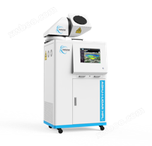
AGHJ-I-LIDAR (HPL) typeAtmospheric particulate matter monitoring lidar (high-energy scanning series)Remote sensing detection of atmospheric particulate matter using pulsed laser with a wavelength of 532nm.
The pulsed laser enters the atmosphere after collimation and beam expansion, interacts with particulate matter in the atmosphere, and generates backscattered light. The scattered signal is received by the telescope system and converged to the optical analyzer system, forming a 532nm parallel and 532nmThe two vertical channel signals are processed by a photoelectric detection system and a signal acquisition system, and the spatial distribution (profile) of the extinction coefficient and depolarization coefficient of atmospheric particulate matter is inverted by a computer. This enables the acquisition of atmospheric quality information such as the spatiotemporal distribution characteristics of atmospheric particulate matter, spatiotemporal changes in the pollution layer, and the transport and deposition of particulate matter.
Product advantages
Excellent hardware specifications: superior time and spatial resolution, high pulse energy, long service life, etc
Flexible observation methods: Multiple observation modes to choose from
Strong environmental adaptability: suitable for harsh environments such as high temperature, high humidity, and high cold
Good equipment stability: stable data quality, low overall failure rate
Diverse application scenarios: multi platform applications such as in car, station building, and shelter
High market recognition: application in multiple fields and regions
Product Application
Vertical scanning detection: inversion of spatial distribution information and spatiotemporal evolution characteristics of aerosol particles within 10km from the ground
Regional point source/area source scanning: Conduct fixed-point positioning scanning of important point sources (including elevated sources) and line sources such as chimneys, boilers, chemical plants, power plants, cement plants, and main transportation roads, mainly to obtain the intensity of source emission pollution
Regional pollutant distribution scanning: achieving quantitative assessment of sensitive areas such as industrial parks, residential areas, and factory areas
Navigation monitoring and scanning: Using the working methods of "parking scanning" or "navigation directional observation", real-time, online, and continuous scanning and monitoring of the input, transit, and deposition processes of pollution clusters over the region, analyzing the types, intensities, and evolution processes of pollutants
Lidar networking monitoring: By constructing a lidar network, dynamic monitoring and tracking of air quality and boundary layer evolution characteristics in key areas can be achieved, effectively identifying the transmission process in the region
Laser wavelength: 532nm
Laser pulse energy: 10 μ J to 1000 μ J
Detection blind spot: ≤ 75m
Time resolution: 3S (adjustable)
Spatial resolution: 5m (adjustable)
Horizontal detection distance: not less than 5km
Scanning method: galvanometer scanning
Scanning module angle resolution: ≤ 0.1°
Scanning range: Horizontal 0 °~360 °, Vertical -90 °~90 °

